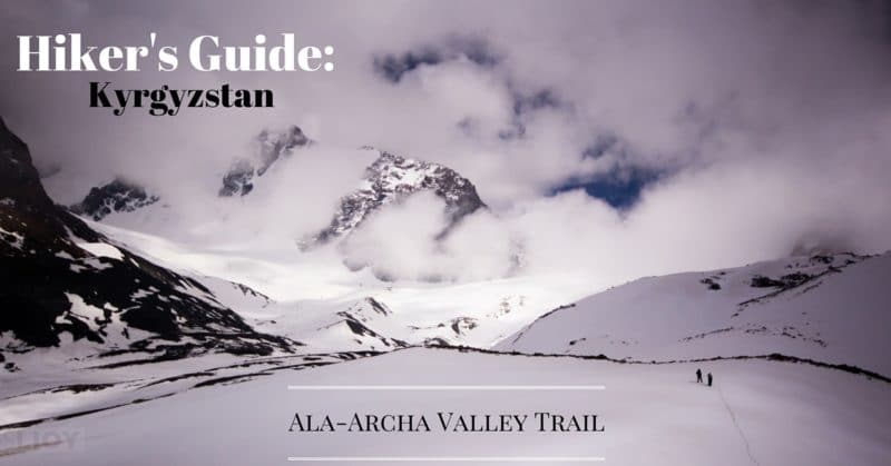
Kyrgyzstan: Ala-Archa Valley Trail
Only a 30-45 minute drive from the capital city of Bishkek, the Ala-Archa Valley Trail inside the Ala-Archa National Park is perhaps the most accessible hiking destination in all of the Kyrgyz Republic. There are several marked trails and a number of unmarked options, but seemingly the most popular is the Ala-Archa Valley itself.
Ala-Archa National Park
Admission Costs [in Kyrgyz Som]:
Adults (80 som)
Students (60 som)
Children 5-12 (25 som)
Passenger Vehicles (400 som)
Getting to the Ala-Archa Valley Trail
To get to Ala-Archa National Park from Bishkek, either take minibus 265 (~$2) from near Osh Bazaar on the NE corner of Toktogul and Beishenaliev (which will leave you several kilometers before the park entrance, to hitch/hike/taxi) or just hire a taxi (around $10 one-way, $25 return with some waiting in between). From the entrance to the park, the road winds up ~12 kilometers before arriving at the alplager hotel and trailheads. Here you can find a small shop selling snacks and maybe a very basic warm meal, or the restaurant at the A-Frame alplager can (eventually) cook a proper feed.
Given the additional hassle involved with getting from the last bus stop to the park entrance and then on the final 12k to the alplager, it’s generally easier just to arrange transport. What may hikers will do is arrange a taxi into the park early in the morning, and then hope to hitch back out with short-term visitors in the afternoon or evening. If it doesn’t work out, there’s always the fallback of the hotel and guesthouse in the alplager area.


Hiking the Ala-Archa Valley Trail
There are several marked trail options from the alplger, up to the Ratsek Hut and a waterfall or to the trekking peak of Pik Komsomolets. Back down the road a short ways, to the west of the road, is a trailhead to the Adygene Valley.
To hike the Ala-Archa valley trail, head straight past the big A-Frame hotel and keep going until the road runs out at a river right past a small yurt tent on a hill to your left. From here the ‘trail’ is an old 4WD track that leads 18km to an old Soviet-era ski base. Walk up the stream a bit towards the mountain wall, and there are several easy crossing points that don’t require getting wet in all the the wettest parts of the year.
About half an hour after leaving the paved road, look for a small trail down to the river on your right where you can cross on a rickety bridge. You’ll cross back over a ways on, but the left (east) side of the river gets a bit tricky to navigate at times so ideally you want to catch the bridge. It can be easy to miss, so be aware and if the east-of-river trail starts to hit scree you’ve gone too far.

After the second bridge, crossing back over the river right below the ‘Top Karagai’ valley above to the east, you’ll go mostly level for a while before a short downhill stretch where the Ala-Archa valley opens up to one of its widest points. This is a far as most daytrippers make it, but if you’re quick or have camping gear the best is still ahead. It’s also possible to detour here up along the Top-Karagai stream to the glacier that starts at around 3680m, but from the Ala-Archa River at 2511m it’s a pretty steep climb over the lateral distance that comes in just below 5km.
Alternatively, at the far end of the same valley just past the second bridge and just before the trail starts to really climb once more, to the southeast the Dhaldisuu River climbs steeply to the foot of the Golubina glacier that stretches waaaaay off to the Ak-Duval Pass about 5km away. It’s rough terrain and I wouldn’t suggest tackling it unless you’re prepared for some proper mountaineering, but if you’re turning around near hear to head back to Bishkek this is a good last scramble to have a glance at it.


After an uphill stretch and around 200m of elevation gain on the main trail you’ll have to ford the river (it gets broader several times, but jump over where you feel most confident) and will eventually hit another open stretch of valley. On the right (west) side up a small hill is an old meteorological station, the back side of which makes for a decent campsite when the wind is too strong on the valley floor. If you’re around near winter at all, this valley may also be the last stretch of non-snowy ground you’ll see for a while.
Continue along the trail to another uphill that eventually tops out at the end of the Ala-Archa Valley and a beautiful bowl surrounded by mountains. In the southeast pocket of the bowl you’ll find the remains of an old Soviet-era Ski Base at 3400m just below the foot of the Ala-Archinskii, Manas, and Toktogula glaciers – a really amazing view. This old ski base is still used by some visitors to get out of the elements for a bit and there are even still mattresses on the first-floor bunk beds if you’re pining for a quick nap after the long walk. If you want to explore the valley’s end a little, look for a small lake to the east (about .5k north of the trail up the Ala-Archa Pass) that stays frozen for much of the year.
It is possible, from here, to take the 3907m Ala-Archa Pass and head further south towards Kochkor. If that isn’t in your plans, though, you’re probably heading north back up the Ala-Archa valley to the alplager or to Bishkek!

Good To Know
Though it’s very possible to explore the mountains of Kyrgyzstan year-round, the best season is generally considered to be July-September. It’ll still be cold at night, often, but snow should be off all but the highest of trails and water will be available on valleys with rivers.
Though there are some facilities at the trailhead in Ala-Archa, don’t expect much. There are certainly no ATMs, sometimes the alplager hotel doesn’t have food, sometimes the small shop/cafe is closed. Try to treat these as conveniences rather than something you can depend on, and bring what you can from Bishkek.

Hiking the Ala-Archa Valley in Winter
Kyrgyzstan’s Tien-Shan mountains get quite a lot of snow in winter (some of which sticks around even through the hottest bits of summer), which obviously means hiking takes a bit more preparation. Of all the trekking trails in Ala-Archa National Park, the Ala-Archa Valley trail is the easiest to hike simply because it’s a relatively gentle slope for much of the way. Snowshoes are ideal, but even just with a good pair of waterproof mountain boots you should be able to get along for a daytrip. As always when hiking but especially in winter, please be sure to carry extra warm clothes and food in the event that things don’t work out perfectly and you get wet or delayed.
As an aside, we’ve also published a quick and dirty guidebook to show tourists around for their first few days in Bishkek. This includes information, including a map, of where to get the minibus to Ala Archa. If you’re headed towards Kyrgyzstan and expect to need some help getting around, consider our Unanchor: Bishkek guide!
If you’re in Bishkek as a tourist the very budget-friendly Apple Hostel Bishkek gets great reviews, as does the slightly more central and also slightly more expensive Interhouse (both of which offer private rooms as well as dorms). If you’re looking upmarket, the Hyatt is on Sovietskaya and still easily accessible to the city center.
Are YOU planning a hiking trip to Kyrgyzstan’s Ala-Archa National Park? Share it with your friends!

Have you hiked the Ala-Archa Valley? If so, let us know what your experience was like and any other tips you think it would be have been ideal to know before you set off!
WARNING: THIS HIKE IS VERY DANGEROUS. We hiked it in August 2023. Only the first bridge still exists, so instead of crossing the river a second & third time, stay on its right side. The path is partly barely visible and be prepared to hike across stone fields, through bushes with thornes and parts of the river. Still, it is kind of safe and definitely beautiful until the valley with the meteorological station. A few kilometers after the station, a river comes down from the mountain to your right. WE WOULD NOT RECOMMEND TO GO ANY FURTHER. Apparently, some stone avalanches came down. You’ll see a stone/dirt wall which you can only climb over big, loose stone fields or the wall itself. Both options are very dangerous. There might be an opportunity to cross the river to the left and find a path through a meadow part left to the stone wall. We haven’t tried that option though. Better be safe and enjoy the views until the meteo valley.
Hi Pauline – the first bridge is still there as of just a few weeks ago, though I can’t speak to the condition past Meteo station as I’ve not been up there for quite a while. Previously we’d climbed onto the old moraine somewhere shortly past the meteo valley near the abandoned tractor, if that’s the area you mean?