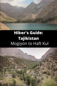
Tajikistan: Mogiyon to Haft Kul Trek
Таджикистан: Могион – Хафт-Куль
Located in the far west of the Fann Mountains, the Mogiyon to Haft Kul Trek combines the off the beaten path village of Mogiyon with a classic Fanns destination in Haft Kul. The Mogiyon-Haft Kul trek is perfect for those looking for a short overnight adventure that’s easily accessible. With a maximum altitude of 3,288 meters, it’s also a good option for those that have just arrived in Tajikistan and are wanting to acclimatize for higher altitude treks later in their trip.
For those short on time but still wanting to squeeze in a trek in Tajikistan, the Mogiyon to Haft Kul hike also offers a good combination of different landscapes ranging from narrow canyons, villages set in green valleys, raging blue rivers, still turquoise lakes, and magnificent alpine scenery.
Total km: 38.5 km
Total days: 2
Elevation gain/loss: 3,159m+/2,825m-
Start point: Mogiyon
Endpoint: Padrud, Haft Kul
GPS Files
The trek from Mogiyon to the Haft Kul is moderately strenuous due to length but is straightforward to navigate as this is a common route used by local shepherds between the two valleys. Following the Subashi River Valley southward, you will break away to the east to climb into Komichura Pass before descending to a Fann favorite- the Seven Lakes, known locally as the Haft Kul. This is a lower altitude trek for Tajikistan, with an elevation of 1,523m in Mogiyon at the start, 3,288m at its highest atop Komichura Pass, and 1,850m at the end in Padrud.
Mogiyon to Haft Kul Trek: Stage 1
Mogiyon to Rogich
Total km: 15 km
Walking time: 4 hours
Total time: 5 hours
Elevation gain/loss: 1572m+/914-
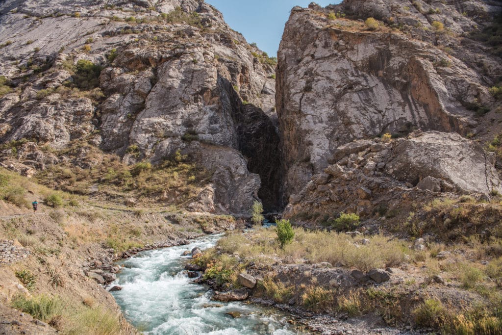
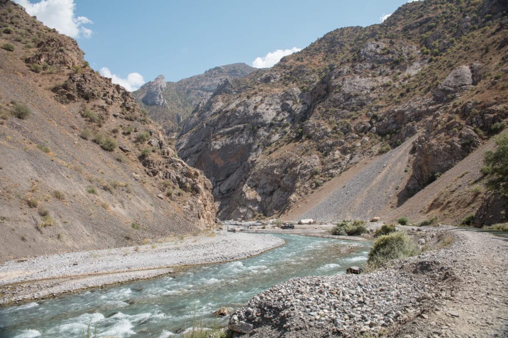
The path leading south from the village of Mogiyon follows the track of an old roadbed, passing through the village orchards along the edge of the Subashi River. Around 1 hour or 3.5 kilometers into the walk, the landscape will become progressively more arid as you leave the green crops and fertile orchards of the village behind for the desertified mountains beyond.
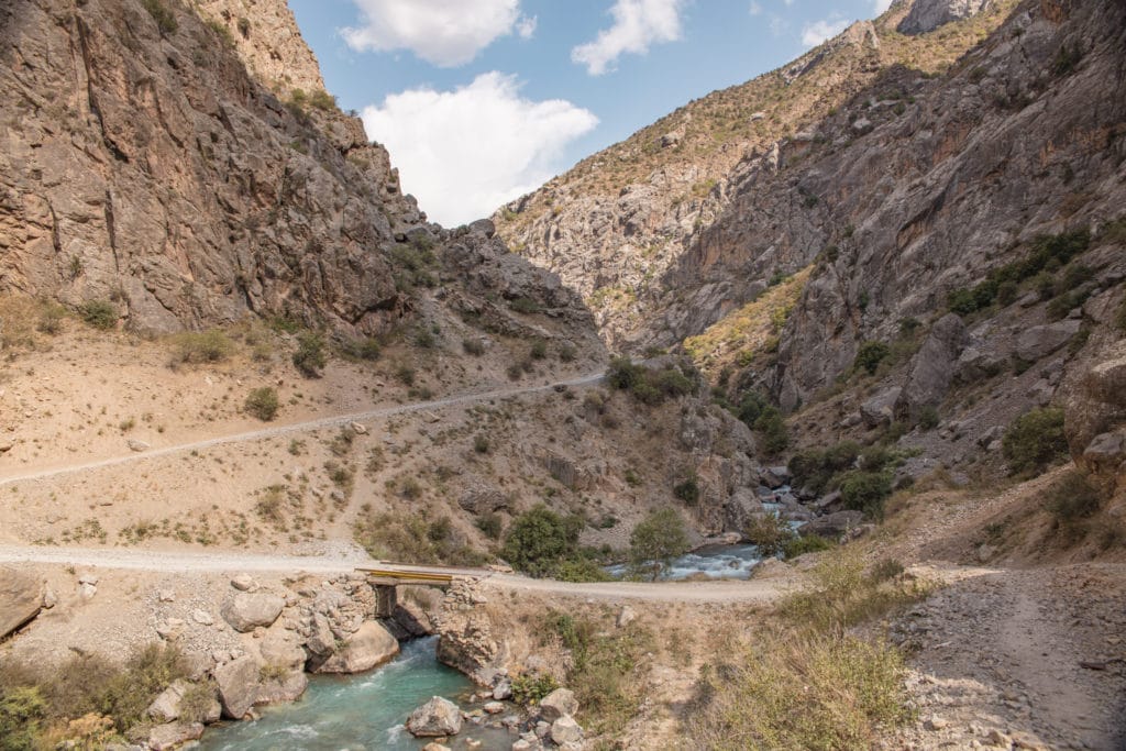
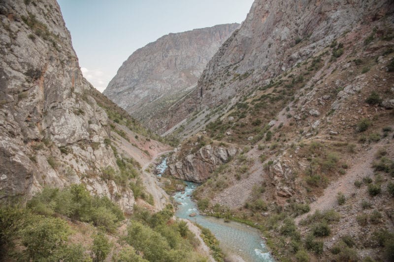
At roughly 4.7 km, the path will need to cross a bridge to the other side of the river as the path starts to curve to the east. You will again cross wooden bridges at roughly 5.7 km and at 7.5 km. The path then bends to the south at 8.5 km to enter into an impressive high-walled canyon cut by the rushing Subashi River where you’ll cross another wooden bridge.
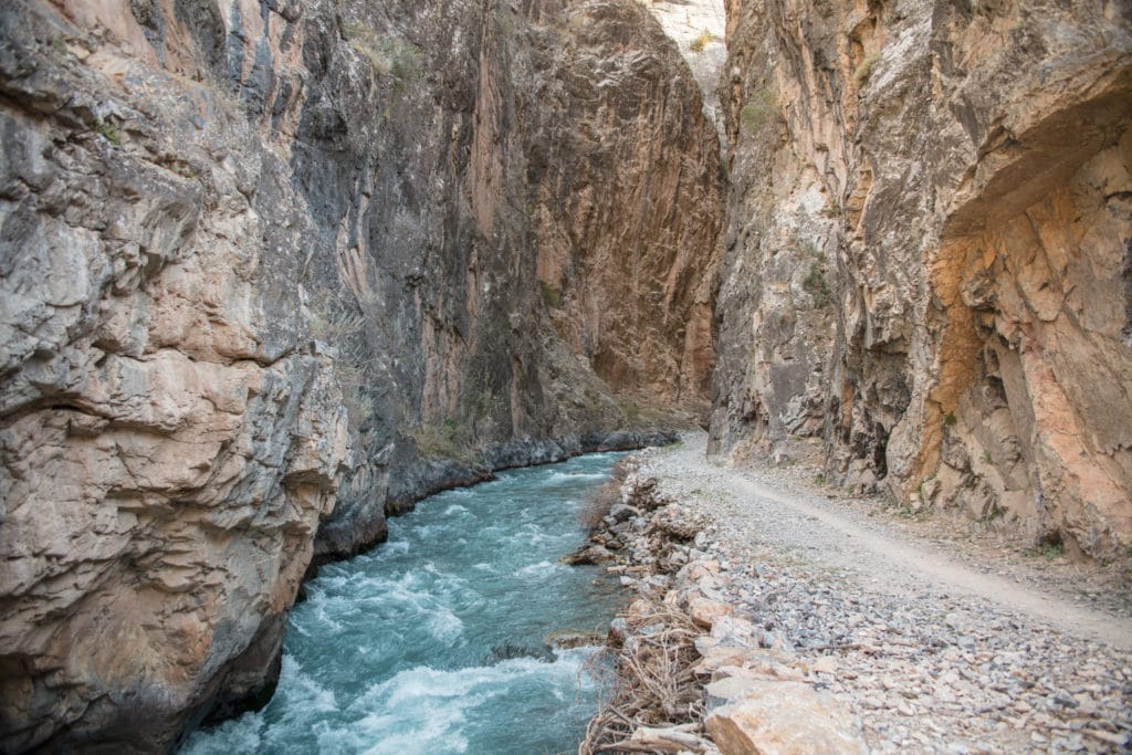
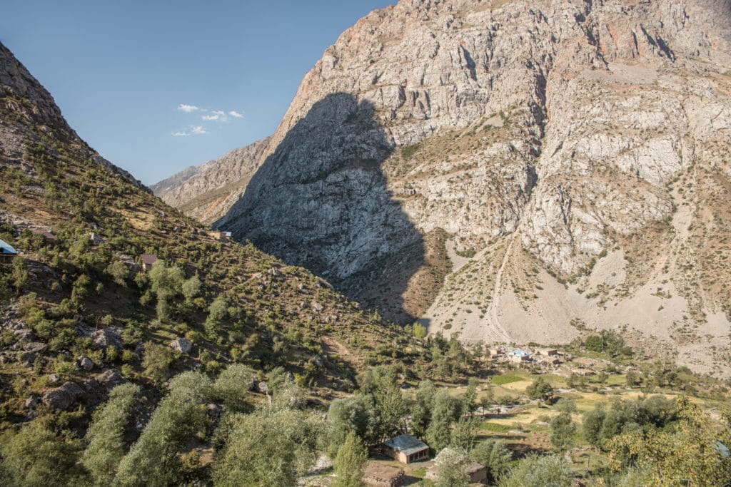
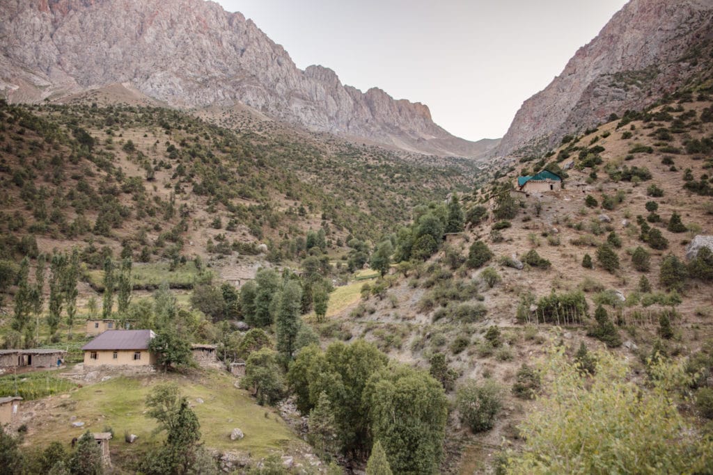
After 300 meters, beyond this narrow canyon, the valley becomes wide and craggy. The trek continues for about 6km further, crisscrossing the river by bridge four more times before arrival inthethe verdant village of Rogich. It’s possible to book a homestay here in the village (contact ZDTA to make arrangements), but it’s also fine to camp nearby.
Mogiyon-Haft Kul Trek: Stage 2
Rogich to Padrud
Total km: 23.5
Walking time: 8 hours
Total time: 9 hours
Elevation gain/loss: 1,587m+/1,911-m
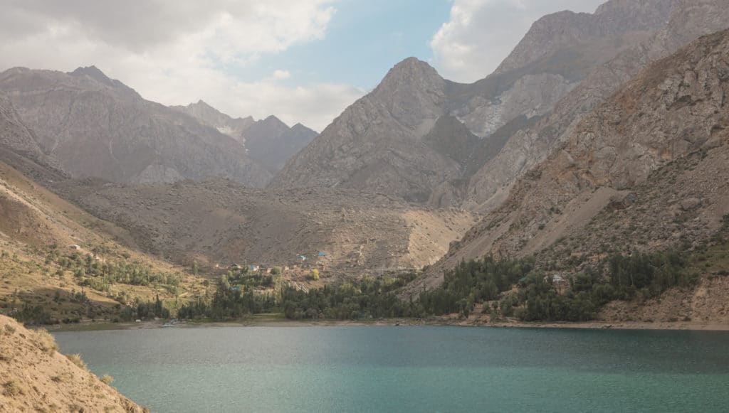
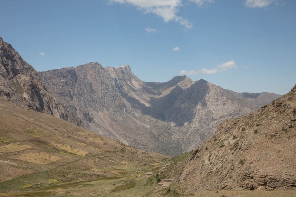
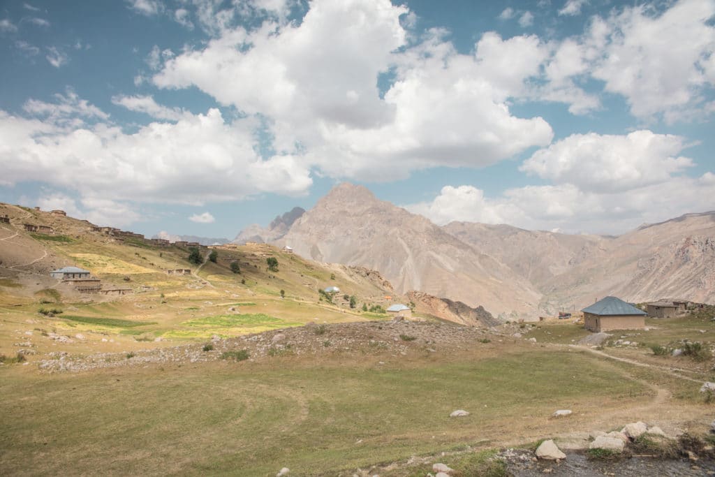
From Rogich, follow the Subashi River Valley due east to begin the trek up to Komichura Pass. The walk is gradual switchbacking up a long valley, climbing about 5 hours from Rogich to the top of the pass, with a sharp dip to the south and back to go around a particularly steep section just before the pass. Arriving at the top of the pass offering views of the 6th lake of Marguzor below, and of the rugged ridges that line both sides of the Haft Kul valley to the north and south.
On the descent you will pass through the mountain village of Soimarguzor on the way to Marguzor below. Once to the bottom of the valley, it’s possible to continue about 1 km further to the south to visit the Seventh Lake of Hazorchazma, or to turn north down the valley immediately upon reaching the lower section of Marguzor.
Continuing to the north, you’ll be walking on a dirt road along the eastern shore of Marguzor lake for about 8 km to reach Padrud. The track continues past the Khurdak lake (lake #5 of 7) before reaching Padrud, a small village where it’s possible to catch a shared taxi out of the valley.
Alternate Options for the Mogiyon-Haft Kul Trek
It is easy to connect the Mogiyon to Haft Kul trek to other routes in the Fanns for those wanting to extend their trek. Follow the path up to Kiogli from the eastern shore of Marguzor. The trail continues up into 3,300m Tavasang Pass before descending into the Sarymat River Valley. From the Sarymat River, there are a number of routes to take you to various destinations in the Fanns including Iskanderkul, Bolshoi Allo, the Kulikalon and Alovaddin Lakes system, among others.
Good to know
There are no entrance fees to this part of the Fann Mountains, though don’t be surprised if one is adopted in the future as the Haft Kul is one of the most-visited destinations in the country.
There is a checkpoint at the village of Shing along the road to Haft Kul. Passports and visas will be checked there, as this is a border zone near the Uzbek border. Copies will not suffice.
It is entirely possible to do the Mogiyon to Haft Kul trek with no camping gear as there are homestays in Mogiyon, Rogich, Padrud, Nofin, as well as a Turbaza on the north end of Marguzor.
Porters and guides are available for those that want them. It’s usually no problem to hire porters/pack animals on the spot, but if you’d like to arrange them in advance, get in contact with ZTDA. Expect pack animal porter service to run about 300 TJS or so per day.
This trek is well marked on apps such as Maps.me, Open Street Maps, and GAIA GPS.
Getting to the Mogiyon to Haft Kul Trek
Getting to Mogiyon is most easily done from the city of Panjakent. Shared taxis depart most mornings from a lot just south of the Panjakent Bazaar for about 75 TJS for a seat (expect to haggle a bit) for the 90 minute journey. Ask around if you’re unsure of where the lot is, people will point it out to you.
Getting back from Padrud after the hike you will find that there is a shared taxi departing on most mornings. Expect to pay about 60 TJS for a seat.
If doing the trek in reverse, the prices are about the same. Haft Kul-bound shared taxis leave near the bazaar in Panjakent. A shared taxi leaves Mogiyon on most days, so enquire with locals or ask your homestay host to help arrange a pickup.
Where to stay and eat
One thing that makes the Mogiyon to Haft Kul trek unique is that there is no need to lug around camping gear if you don’t want, as you can trek from homestay to homestay quite easily. Homestays are available in Mogiyon, Rogich, Padrud, Nofin, and a Turbaza on the north end of Marguzor. Plan to pay around 285 TJS per night for a bed along with dinner and breakfast. If you’d prefer to make bookings in advance, the Zerafshan Tourism Board in Penjakent can help either via email or at their office in Penjakent.
There are several small stores as well as the larger Panjakent Bazaar to pick up provisions for the trek before you leave Panjakent.
[All photos courtesy of Adventures of Nicole]
![]()
Pingback: Tajikistan: Fann Mountains Trekking Guide - Asia Hikes
Hello everyone,
First I really want to thank you for this blog and the comments that really helped us to prepare this trek in Tadjikistan.
We are a couple (male and female) travelling in Ouzbékistan and wanted to cross the border to trek in high mountains in Tadjikistan in June 2025.
Since I am not English native, will you please forgive me for any grammatical mistakes 🙂
Some advice :
1. People we met do not speak English at all and there is no network nor wifi but they speak Russian. I highly recommend to download Russian dictionary either in your phone working without wifi.
2. I am a female and all women I met had hair covered. I think it is respectful to wear a veil but it is up to you. Also, we were welcomed by men only, and I do not know whether I would have been travelling with a female friend we would have been welcomed the same way. Men we met almost only spoke to my husband and barely looked at me. I do not mind it since I know each country or areas got their own codes, cultural and religious ways of life and I am fine with it.
3. Maps.me is perfect for this trek and it is free.
Day 1 : Samarkand to Moghiyon
Day 2 : Moghiyon to Roghich
Day 3 : Roghich to Padrud
Day 4 : Padrud to Samarkand
You can easily find a shared taxi from Samarkand to the border (15000 SUM per person maximum, do not pay more! You can even try to negotiate down to 10000 SUM). It is about 1h30 depending on the traffic. Then crossing the border is super easy and fast, you can also exchange money there from sum to tadjik.
Then you can get into another shared taxi easily to go to Penjakent (20 minutes, 15 Somoni per person).
Once in Penjakent, you can ask taxi to drop you off at the bazar where you can do some food shopping. Then you can ask anyone shared taxi to Mogiyon and people will help you to go to the right place around the bazar for the cars going there.
The ride is 70TJS per person you can try to negotiate better but do not pay more than 80 TJS. Also, please consider that you might get into a car with many many people. We were 20 people inside monospace car which was crazy but funny too. Ride is about 1h30 to get to Mogiyon. Once we got there we asked people in the street for guesthouse or hotel since we haven’t booked anything and did not bring any camping gears with us.
They kept telling us that there were no hostels in town until a guy asked us to follow him and introduce us to an old man kind of imam who let us use a room with mattress and blankets probably use for Muslim during prayer or people in need, hard to say … since he could not speak English at all, and there was no network to translate on our phone, it was hard to communicate but still we managed to get understood.
We had tea in the afternoon, then dinner (a pilov) then breakfast. We felt very lucky and welcomed here. There were no shower and only Mongolian style toilet 50m away from the house.
The next morning, just after breakfast we asked how much we could pay but he kept saying niet niet so we found out it was all for free.
We left the village and started to walk at 07.30 am.
First the path is a dirt road used by car and some of them stopped by and kept asking whether we needed a lift an d then after 2km we were on our own following the river. The walk is pretty easy, sometimes we need to climb a bit but nothing too hard. As it was in early june, the valley was really green and the river was running strongly.
We arrived at Roghich village after walking 4 hours and a half. Right before the village, a guy with his donkey introduced himself and asked us to follow him. He introduced us to an old guy who was also kind of « chef of the village » and opened a small house, exactly same type we had on the previous night with carpets and blankets on the floor. He could not speak English at all but we manage to understand that we could stay here for rest. It was around noon and he came back with lunch (which was a pilov) and tea and bread of course. Then we had some rest in the afternoon and we went up in the village to visit. At night the guy came back with dinner (a rich and thick soup with potatoes and sheep which was delicious, bread and tea). We tried to tell him that we needed to leave early in the morning and how much we had to pay for accommodation and food but we understood that once again it was for free. Anyway, we left early in the morning (around 6.00 am) without seeing him and we put equivalence 30 dollars in TJS under a tea cup to thank him.
There is a pretty hard climb from the village up to Komichora pass, it took us 4 hours but the view is amazing, everything was so green, birds singing, differents flowers and plants, sun rising as cloud were falling down. Everything is peaceful, we were completely alone. The path follow the river and you can see the irrigation system made by the people living around. At 3000m, there is a small farm and house it is good to know in case you would need to drink some hot tea 🙂
Path is really well indicated on MAPS.ME.
Once you get to Komichora pass, the descent is ok until Soimarguzor village as you are still in the valley but then it is a dirt road which is not nice for the knees ! We turned right before arriving to Marghuzor to see the 7th lake and had a picnic there.
Then we went to Padrud, walking in the dirt road along the 6th and 05th lake. There were many cars coming/going back from/to Penjakent so be careful and also you can hitchhike this part of you are not enjoying the walk or if too tired.
In Padrud we slept at Mijgon guesthouse which is indicated on MAPS.ME.
Total : USD 25 / pers for night, dinner, breakfast. Shared bathroom and toilet, it was nice to have an hot shower. Meals were ok.
In the morning after at 05.00 am we took a shared taxi back to Penjakent. We asked the guesthouse to arrange it for us. But you can go to the school (indicated on maps.me) from where shared taxi usually leave very early. Ride is 2 hours and we negotiate 70 TJS / pers. I am pretty sure you can hitchhike during the day with the cars that do one day trip to seven lake and go back to Penjakent or Douchanbé.
Then we went back to Samarkand very easily.
We highly recommend this 2 days trek and we were frustrated to leave Tadjikistan so quickly but we will come back for others treks that’s for sure.
Hi Pauline, thanks for the detailed info!